|
Barometric Survey
|
Draped Survey
|
|
Link
|
 
|
|
|
Gravity
|
 LOAD JPEG IMAGE
|
 LOAD JPEG IMAGE
|
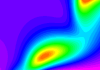
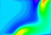
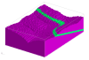
| In
this image the distance to the top of the body controls the local strength
of the anomaly, with the hill outcrops dominating the survey. |
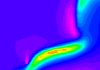
With
a draped survey the anomaly strength actually peaks at the base of the
valley. |
|
Magnetics
|
 LOAD JPEG IMAGE
|
 LOAD JPEG IMAGE
|
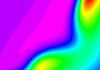
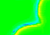
| As
with the gravity image, the magnetic survey mainly reflects the variable
distance between the outcrop and sensor. |
In
this model the geometry of the body is more clearly defined, however there
is a distinct asymmetry between North- and South-facing slopes, with the
high susceptibility layer significantly weaker on the South-facing slope. |
|
Magnetics
|
 LOAD JPEG IMAGE
|
 LOAD JPEG IMAGE
|
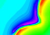
| As
with the gravity image, the magnetic survey mainly reflects the variable
distance between the outcrop and sensor. |
In
this model the geometry of the body is more clearly defined, however there
is a distinct asymmetry between North- and South-facing slopes, with the
high susceptibility layer significantly weaker on the South-facing slope. |
|
Magnetics at Pole
|
 LOAD JPEG IMAGE
|
 LOAD JPEG IMAGE
|
| As
with the -50° inclination model, the magnetic survey mainly reflects
the variable distance between the outcrop and sensor. |
In
this model the geometry of the body is still more clearly defined, and
the anomaly strength is more uniform along strike. The local fluctuations
in anomaly strength along the length of the body reflect the discretisation
of the land surface into cubes. |
|
Magnetics at Pole 1VD
|
 LOAD TIFF
IMAGE
LOAD TIFF
IMAGE
|
 LOAD TIFF
IMAGE
LOAD TIFF
IMAGE
|
| As
with the pole image, the magnetic survey mainly reflects the variable distance
between the outcrop and sensor. |
In
this model the geometry of the body is more clearly defined as a linear
dipole anomaly. The local fluctuations in anomaly strength along the length
of the body reflect the discretisation of the land surface into cubes.
(The look up table of this image has been clipped to show more detail.) |


)
)
)
)
)
)
)
)
)
)
)