|
Barometric Survey
|
Draped Survey
|
|
Link
|
 
|
|
|
Gravity
|
 LOAD JPEG IMAGE
|
 LOAD JPEG IMAGE
|
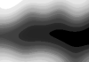
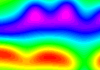
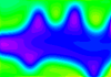
| In
this image the gravity field only reflects the general shape of the topography,
and the position of the high density layer is not immediately obvious. |
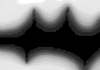
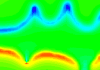
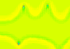
In
this image the gravity field reflects the shape of the topography, and
the sharp gradient (which follows the contours) marks the position of the
high-density layer. |
|
Magnetics
|
 LOAD JPEG IMAGE
|
 LOAD JPEG IMAGE
|
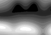
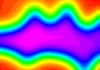
| In
this image the magnetic field only reflects the general shape of the topography,
although there is a strong asymmetry between the North and South facing
slopes of the valley, and the exact position of the high susceptibility
layer is unclear. |
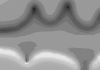
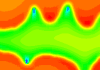
In
this image the magnetic field reflects the shape of the topography, and
the position of the high susceptibility layer is marked by a low contour-following
low on the South-facing slope, and a contour-following high on the North-facing
slope. |
|
Magnetics
|
 LOAD JPEG IMAGE
|
 LOAD JPEG IMAGE
|
| In
this image the magnetic field only reflects the general shape of the topography,
although there is a strong asymmetry between the North and South facing
slopes of the valley, and the exact position of the high susceptibility
layer is unclear. |
In
this image the magnetic field reflects the shape of the topography, and
the position of the high susceptibility layer is marked by a low contour-following
low on the South-facing slope, and a contour-following high on the North-facing
slope. |
|
Magnetics at Pole
|
 LOAD JPEG IMAGE
|
 LOAD JPEG IMAGE
|
| In
this image the magnetic field only reflects the general shape of the topography,
and since this image is calculated at the South Pole, the North- and South-facing
slopes behave in the same way. The exact position of the high susceptibility
layer is unclear. |
In
this image the magnetic field reflects the shape of the topography, and
the position of the high susceptibility layer is marked by a sharp transition
in intensity values. |
|
Magnetics at Pole 1VD
|
 LOAD TIFF
IMAGE
LOAD TIFF
IMAGE
|
 LOAD TIFF
IMAGE
LOAD TIFF
IMAGE
|
| In
this image the magnetic field only reflects the general shape of the topography,
and since this image is calculated at the South Pole, the North- and South-facing
slopes behave in the same way. The exact position of the high susceptibility
layer is roughly marked by the sharp transition in intensity values. |
In
this image the magnetic field reflects the shape of the topography, and
the position of the high susceptibility layer is marked by a contour-following
dipole anomaly. |

)
)
)
)
)
)
)
)
)
)
)